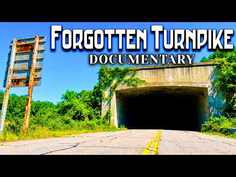
Walking The Sealed Pennsylvania Turnpike
Breezewood, Pennsylvania
39.9994 N, 78.2397 W
Deep in the Allegheny Mountains, there's a highway that leads nowhere. Seven tunnels carved through solid rock. Thirteen miles of crumbling pavement. Guardrails twisted by decades of freeze and thaw. This was once part of America's most advanced toll road--until the day engineers simply drove around it.
The abandoned section sits between Breezewood and Fort Littleton in south-central Pennsylvania. Two lanes disappearing into mountain darkness. Exit ramps to exits that no longer exist. A highway frozen in 1968, the year the final toll was collected and the gates closed for good.
It wasn't closed because of disaster or decay. It was abandoned because of geometry.
The Impossibility of Travel
In the 1930s, Pennsylvania faced a problem that seemed impossible to solve. The state stretched 283 miles from Philadelphia to Pittsburgh--two major industrial centers separated by the Appalachian Mountains. Travelers had two choices: drive narrow mountain roads that twisted through valleys and over ridges, or take the long route north through New York.
The journey from Philadelphia to Pittsburgh took fourteen hours on the best days. In winter storms or fog, it could take twenty hours or more. Trucking companies avoided the route entirely. Pennsylvania's two great cities might as well have been separated by an ocean.
Vanderbilt's Abandoned Dream
The solution had been proposed before--build a highway straight through the mountains. But the cost seemed impossible until 1937, when the federal government made an offer. The Pennsylvania Turnpike Commission could use an abandoned railroad corridor, including seven partially completed tunnels, left over from a failed rail project begun by Cornelius Vanderbilt in 1883.
The tunnels had been sitting unused for fifty-four years. Vanderbilt's South Pennsylvania Railroad was meant to compete with the Pennsylvania Railroad, but financial backing collapsed before a single train ever ran the route.
Building America's First Superhighway
Between 1938 and 1940, the Pennsylvania Turnpike Commission employed 13,000 workers to complete what Vanderbilt had started. The tunnels required finishing. Roadway had to be graded across 160 miles of mountain terrain. Bridges, interchanges, toll plazas--all had to be built from scratch.
The total cost: $70 million. In today's dollars, that's roughly $1.5 billion.
When the Pennsylvania Turnpike opened on October 1, 1940, it was revolutionary. A four-lane limited-access highway where drivers could maintain highway speeds without stopping for traffic lights or intersections. The newspapers called it "the greatest engineering marvel since the Panama Canal."
The turnpike cut the Philadelphia-to-Pittsburgh drive time in half. What once took fourteen hours now took seven. The tunnels--Allegheny Mountain, Tuscarora, Kittatinny, Blue Mountain, Sideling Hill, Rays Hill, and Laurel Hill--became the highway's signature feature.
The Success Problem
But there was a problem built into the design. The tunnels were only wide enough for two lanes--one in each direction. When traffic was light, this worked perfectly. But the turnpike became far more successful than anyone had predicted.
In the first year, 2.5 million vehicles used the road. By 1950, that number had grown to 10 million. By 1960, it reached 20 million annually. The tunnels became bottlenecks. Traffic backed up for miles, especially during summer travel and holiday weekends.
Inside the tunnels, conditions grew dangerous. Two-way traffic with no shoulder, no escape lanes, and limited visibility. The longest tunnel--Sideling Hill--stretched 6,782 feet through the mountain. Rays Hill ran 4,727 feet. In both tunnels, drivers found themselves in complete darkness, surrounded by oncoming traffic just feet away.
The Bypass Decision
Engineers faced a choice. They could widen the tunnels--an expensive, disruptive project that would require closing the turnpike for months--or they could build around them.
In 1964, they chose to build around them.
The new route bypassed the problematic section entirely. It added 13 miles of new highway with four lanes, modern grades, and no tunnels. The cost was $90 million--more expensive than widening the tunnels, but it offered something widening couldn't: immediate capacity with no disruption to traffic.
On November 26, 1968, the bypass opened. The old route through the seven tunnels was closed. Toll collectors packed up. Gates came down. And thirteen miles of America's first superhighway became instantly obsolete.
What Remains Today
The abandoned turnpike sits mostly as it was left in 1968. The pavement has cracked and buckled. Vegetation grows through the roadway. Inside the tunnels, graffiti covers the walls--layers of paint and messages from decades of urban explorers.
In 2001, the Southern Alleghenies Conservancy purchased the abandoned section for $1. It's now part of the Pike2Bike trail, a hiking and cycling path through the tunnels.
On weekends, hundreds of visitors walk through the darkness, headlamps cutting through the blackness, footsteps echoing off tile walls installed in 1940. The tunnels that once carried the future of American transportation now carry people on foot, cameras in hand, looking for a piece of history most drivers bypassed without ever knowing it existed.
The Numbers
- 13 miles: Length of abandoned section
- 7 tunnels: Allegheny, Tuscarora, Kittatinny, Blue Mountain, Sideling Hill, Rays Hill, Laurel Hill
- 6,782 feet: Length of Sideling Hill Tunnel (longest)
- 28 years: Time between opening (1940) and abandonment (1968)
- $70 million: Original construction cost (1938-1940)
- $90 million: Cost of bypass (1960s)
- November 26, 1968: Last day of operation
How to Visit
The Pike2Bike trail is open to the public for hiking and cycling. The tunnels are completely dark--bring a powerful light source. The surface is uneven with debris and water. Cell service is unreliable.
The abandoned highway is accessible from Route 30 near Breezewood. Parking is available at both the eastern and western entrances.
Previous
Atlantic City: Steel Pier After The Spotlight
Atlantic City, New Jersey
Next
Inside Centralia: The Town Burning For 60 Years
Centralia, Pennsylvania
Related Stories
Bedford and Fulton counties, Pennsylvania
The Forgotten Story of America's Abandoned Turnpike: Pike2Bike Documentary
Pennsylvania's abandoned Pike2Bike corridor began as an unfinished Gilded Age railroad, became part of America's first superhighway, and was abandoned again when traffic outgrew its tunnels.
St. Thomas, Nevada
The 100-Year MISTAKE Hiding Under Lake Mead
St. Thomas was drowned to build Lake Mead, then reappeared when a century-old Colorado River math error finally collided with reality.

Johnstown & St. Michael, Pennsylvania
How America's Richest Men Got Away With 2,209 Murders
The Johnstown Flood was not only a storm disaster. It was a preventable engineering failure tied to elite negligence and a legal system that failed 2,209 victims.